
Cameroon
Cameroon is called Africa in miniature, because it has almost every landscape found on the continent inside one country.
- CapitalYaoundeThough Douala is the largest city
- PopulationAbout 28 millionIn central-west Africa
- Area475,442 km2Desert, savannah, forest and mountains
- LanguagesOver 250Plus French and English as official
Cameroon is nicknamed Africa in miniature because it contains beaches, rainforest, savannah, mountains and the edge of the Sahel all in one place. Mount Cameroon, an active volcano near the coast, rises to 4,040 m.
The country was split between British and French rule after the First World War, which is why it has both English and French as official languages. Tension between the francophone majority and the anglophone regions has led to serious conflict since 2016.
National symbols
- National animal Lion
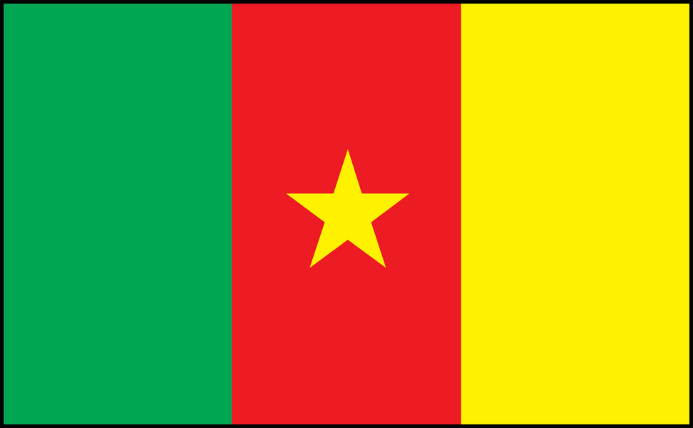
- National colours Green, red and yellow
- National anthem O Cameroon, Cradle of Our Forefathers
- National day National Day, 20 May
Map of Cameroon
Geography
Cameroon covers 475,442 km2 and borders Nigeria, Chad, the Central African Republic, the Republic of Congo, Gabon and Equatorial Guinea, with a coast on the Bight of Biafra.
Mount Cameroon, an active volcano, reaches 4,040 m near the coast and is one of the wettest places in Africa. Rainforest covers the south, savannah the centre, and the far north reaches Lake Chad and the Sahel.
Climate
The south is equatorial: hot, humid and wet with two rainy seasons. Debundscha, at the foot of Mount Cameroon, receives around 10,000 mm of rain a year, one of the highest totals on Earth.
The centre has a single wet season, and the far north is hot and semi-arid with a short rainy season. The harmattan blows Saharan dust south in the dry months.
Famous landmarks
There are numerous impressive landmarks, monuments and buildings in Cameroon including the Foumban Royal Palace & Museum, Reunification Monument, Dika Akwa Palace, Fon's Palace, Kribi Lighthouse, Londji Bimbia (historical slave port), Le Monument aux Morts, Statue of Charles Atangana, Cathedrale Saint-Pierre-et-Saint-Paul, Cathedrale de la Paix, Kumbo Cathedral, Edea Cathedral, Central Mosque, Basilique Marie-Reine-des-Apotres, Foumban Mosque, New Bell Mosque, and Lamido Grand Mosque.
The tourism industry in Cameroon is steadily improving and the country welcomes visitors to enjoy its stunning landscape and wildlife. The main tourist hotels are located in the country's two largest cities of Douala and Yaoundé, and in the main coastal resorts of Limbe and Kribi which offer excellent beaches. There are many things for tourists to see and do in Cameroon but visitors are advised to check first before venturing away from the main tourist routes. Safety can be an issue in some areas of the Cameroon so tourists should remain vigilant.
Cameroon is famous for for its attractive scenery, unique geographical features, natural landmarks and stunning wildlife. Cameroon produces cocoa, coffee, bananas and many other products for major export.
Culture
French and English are both official, a legacy of divided colonial rule, and over 250 local languages are spoken.
Around 55 per cent of Cameroonians are Christian and around 38 per cent Muslim, mostly in the north. Makossa, a dance music from Douala, became internationally known through Manu Dibango. Traditional kingdoms in the Grassfields still have their own palaces and regalia.
History
The history of Cameroon, as we are able to trace it, began around the 6th century BC with early inhabitants that resided by the Chari River south of Lake Chad. These early human beings including the Sao civilization who lived in this area of Middle Africa for hundreds of years, right up until around the 16th century when Islam impacted the identity of the Sao culture. The Baka people were also among some of the Cameroon's earliest inhabitants. They lived among the rainforests in the southeastern part of the country. European explorers began to settle, beginning with the Portuguese who arrived in the 15th century, naming the region Rio dos Camarés meaning Shrimp River. By 1884, the area had become a German colony known as Kamerun. Following WWI, the region was divided between France and the United Kingdom (League of Nations).
Independence was outlawed during the 1950s by France, and sparked the outbreak of the Cameroonian Independence War (guerre cachee) in 1955. The fight for independence was long and bloody, resulting in thousands of civilian deaths. Cameroon gained independence in 1960 but conflicts continued. This part of Africa has since gained political and social stability, and the economy continues to strengthen. In 1972, its name was changed to the United Republic of Cameroon and in 1984 to the Republic of Cameroon.
Economy
Oil is the largest export, followed by cocoa, coffee, cotton, timber and bananas. Cameroon is one of Africa's significant cocoa producers.
The port of Douala serves not only Cameroon but also landlocked Chad and the Central African Republic. Agriculture employs the majority of the population.
The flag
Three vertical bands of green, red and yellow with a gold five-pointed star in the middle of the red band.
These are the pan-African colours. Green stands for the forests of the south, red for unity, and yellow for the sun and the savannah of the north. The single star is called the star of unity, reflecting the joining of the formerly British and French territories.
